|
Course: Kirkby Slate Road Hill Climb
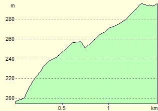
Length: 0.9 miles
Ascent: 100 metres (approx)
| Records |
Date |
Time |
Rider |
Club |
| Course record |
24-Sep-2025 |
03:56 |
Tom Stephenson |
Hope Factory Racing |
| Club record |
21-Sep-2022 |
03:58 |
Dave Huck |
|
| Ladies Course record |
16-Sep-2020 |
04:51 |
Christina Wiejak |
Jadan CycleSpace |
| Ladies Club record |
21-Sep-2022 |
05:13 |
Tamsin Vicary |
|
This is a single track dead end rough track
course. The climb rises 100m in 0.9 miles from the crossroads west
of Netherhouses/Broughton Beck to the wind turbine electricity sub station
on the top of the moor. NOTE this starts off as a normal road surface but
quickly becomes a rutted track. There is a slight fast drop in the middle
then the rest of the climb is very rough with potholes, gravel and serious
erosion.
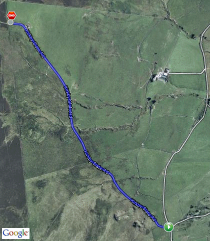
Where is it?
This is the road heading towards the Kirkby Moor wind-farm located
roughly half-way between Ulverston and Grizebeck village as the crow flies.
There are no nearby postcodes available that I can find. The nearest
building is Rake Farm which is just West of Netherhouses in Osmotherley
parish. From Barrow/Ulverston, head to Horrace farm crossroads (SATNAV-
LA12 7SB) then take the road that rises in a north westerly direction. Keep
going until coming to the first crossroads. Turn left. For anyone who is
good with maps, start at a point close to crossroads at GR SD268818.
Parking and Safety
NO VEHICLES TO BE TAKEN UP THE TRACK (except timekeeper). Parking is
recommended in the lane heading down from the crossroads towards Netherhouses and drivers are asked to consider all road users when leaving
the vehicle.
THIS COURSE IS RECOMMENDED FOR MOUNTAINBIKES / CYCLOCROSSERS /
ROUGH HACKS. It is your responsibility to ensure you turn up with suitable
equipment for the course. Carbon framed super-lightweight road bikes/wheels
are not recommended. Riders are requested to take extreme care when
descending the course (preferably walk with the bike) to avoid any issues
with persons racing at that time.
|